Bicycling on the Polar Sea

Thirty years ago this week, near the end of my first winter in the Northwest Territories, I completed a bike ride I’d been planning for months: north along the Mackenzie River ice highway from Inuvik to the coast, and then across the sea ice to Tuktoyaktuk.

The journey seemed like the sort of thing one might want to blog about – except that “blog” wasn’t yet a word and the World Wide Web had not been invented.

In the hope that 30 years late is better than never, here’s that blog post now.

(Note: this ice highway closed for the season for the last time in April, 2017, and has since been replaced by the four-season, gravel surface Inuvik-Tuktoyaktuk Highway.)


Wednesday April 5, 1989 – near Reindeer Station

How do you bicycle from Inuvik to Tuktoyaktuk? You ride north down the Mackenzie River, about 160 kilometers. At the mouth of the river you hang a right onto the Beaufort Sea, and after about 30 more kilometers, just past the pingos, you roll ashore into downtown Tuktoyaktuk.

Obviously you don’t want to try that in the summer, because the carefully maintained ice highways of Canada’s western arctic region wash out to sea by the end of May. And it’s tough to do in winter – the sun shines not at all or only a few hours, and the temperature stays at –40° for days on end.

I had slept outside in temperatures of –40, but only when I was a short walk away from Inuvik where I could go inside and warm up for the day. And I wasn’t particularly keen to be out in the mid-winter deep freeze for days on end.

So I planned my ice-road excursion for the Arctic spring, when the sun shines past 10 at night, the mercury might rise to above zero during the day, and a cyclist can get a deep northern suntan all the way from chin to forehead.

Being a cautious sort, I still wanted to be prepared in case a spring blizzard blew in, dropping temperatures to the –30°C range. This meant I needed big boots, down pants, down parka, sheepskin face mask, and my biggest mittens – all articles of clothing I couldn’t wear while riding because they were too warm, but things I would need if I had to sit out a storm. Adding all that to two down sleeping bags and a ThermaRest mattress made for a big load, and I spent many hours figuring out how to pack it all so that everything was convenient to get at but still balanced on the bike.

And then there was the question of food. Even on a two- or three-day ride to Tuktoyaktuk I would burn a lot of energy, but what if I were stranded by a blizzard? I decided to take enough food for a week. A big bag of caribou meat, which I had sliced thin and dried earlier in the winter, would be my main protein source. Since the meat was lean and wouldn’t provide nearly enough calories, I also carried a bag of rolled oats, another of toasted buckwheat, and several sticks of butter. (Winter camping is so convenient! You don’t have to worry about your butter getting soft and messing up your bags.) With clean snow to melt I didn’t need to carry water, but the gear and food still added up to an extra 50 kilos on my bike.

The weather was warm as I left Inuvik – about –10°C – but snow soon started to fall and a north wind blew it into my face. I settled into a comfortable pace, at which I would produce just enough body heat to keep myself warm but not so much that I would work up a sweat. The road was generally smooth with a thin layer of hard-packed snow along the edges to give me traction. Here and there I would encounter 50 meters or so of glare ice, and on one such patch I took a tumble. I was unable to get enough footing to lift my loaded bicycle upright, and I had to drag it back to road’s edge before I could stand it up. Thereafter I got off and shuffled across any unavoidable patches of glare ice.

I was told I could see Reindeer Station – for several decades headquarters of the Canadian government’s experiment in arctic ranching – from the river bank at km 55. I found cabins, locked, and dog teams, barking, but no humans to inquire of. I walked my bike up a snowmobile trail into the woods and made my camp about 6 pm. By then the sun had emerged and in the shelter it was cozy. The forest provided escape from the wind, and black spruce branches and dry willow twigs made for a roaring campfire – a luxury I didn’t count on finding after another day’s ride north.

When I put on my sheepskin face mask that night to settle into sleep, I was surprised to find my cheeks and nose uncomfortably hot. In spite of the cloudy sky, and in spite of the fact that I had faced north almost all day, enough sunlight had reflected off the snow to give me a sunburn, which I hadn’t noticed as long as cool air acted as a local anæsthetic.

Thursday April 6, 1989

Where am I tonight? Something like 75 km north of Reindeer Station, overlooking a wide channel of the Mackenzie River, relaxing in my sleeping bag in a trench in a snow bank.

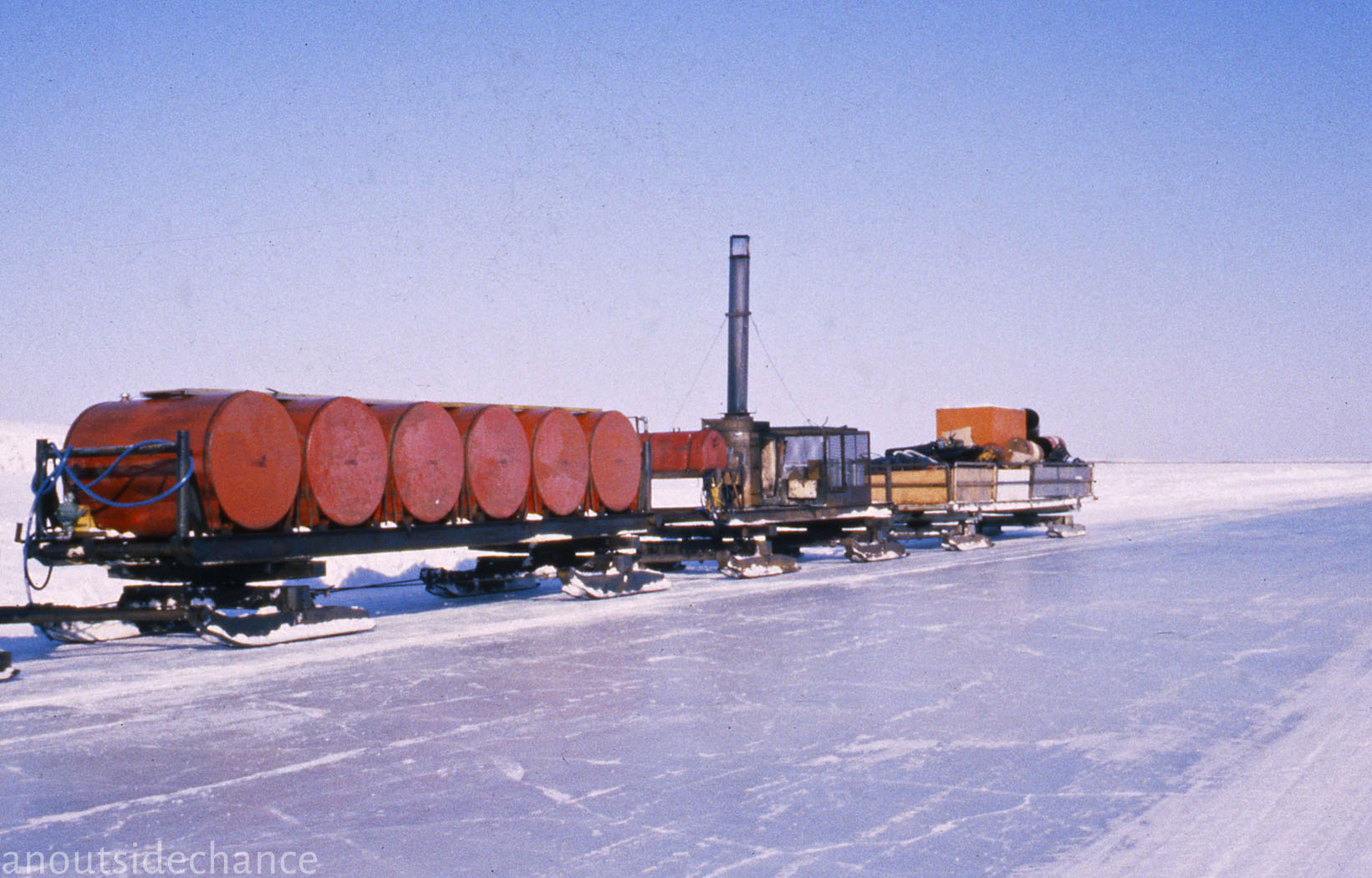
I had intended to spend this morning hiking to the abandoned buildings of Reindeer Station. But by the time I’d eaten my porridge there was a strong south wind and I decided to take advantage of it right away. I pedaled north and watched the trees flanking the Caribou Hills to the east dwindle and then disappear. Every half-hour or so a pick-up truck or semi-trailer passed me, usually bringing curious stares, friendly honks of the horn, and occasionally an offer of hot tea from a thermos. At midday I saw a curious apparition slowly approaching on the northern horizon. A massive tractor was creeping down the road toward me, pulling twenty trailers on skis. The oil companies were concluding their winter drilling activities, pulling equipment away from drilling platforms out on the sea ice.

By late afternoon I was beyond the tree line. The scenery was big, hills rolling away gently forever; the scenery was small, ripples in the snow, little wind sculptures mirroring the topography of the hills themselves, and when I looked down while walking I felt like a ten-thousand-meter giant gazing at distant mountains from on high. At the top of the world I had found heaven, and I wanted to bask in the sunshine savoring this season of light.

I knew the Beaufort coast was only a few hours ahead, and then another hour or two would bring the end of a trip I’d anticipated all winter. I didn’t want the journey to finish for another day so I stopped riding at five p.m. From the snow-plowed road along the ice I searched the landscape for shelter. At a curve in the river, it appeared, the wind would blow directly over the five-meter bank, leaving in its lee a calm space in which I could make my bed. I hoisted the loaded bike over the windrows that marked the highway and set off for my place in the sun. The wind-blown snow was not quite hard enough to pedal across but firm enough that if I got off and walked, the bike rolled along smoothly beside me. After ten minutes I was home for the night.

The first item to come out of my packs was a snow knife. The winter’s winds had piled more than three meters of snow here, packed in a 45° slope. After a half-hour’s work I had cut out enough blocks of snow to make a nice flat trench to sleep in, with the bigger blocks stacked around the head end to further shelter me from eddies in the breeze and to reflect the sun shining directly at me from the far side of the river. Out from the packs came the mattress and sleeping bags, the down parka and down pants, the heavy mitts and felt-lined boots – no sense catching a chill while basking in the sun.

After a short rest I took a half-hour hike up over the river bank and into the brisk breeze on the hills. There I was able to gather a big armload of branches from willow shrubs. Back at my sheltered camp, the twigs burned as fast as I could throw them onto the fire, but with constant tending of the blaze I managed to create hot water from heaps of snow.

Supper’s opening course was hot tea and cold kwok – thin slices of raw frozen caribou meat. Then came the house special – boiled caribou and buckwheat stew. Around 10:30, as the sun-dogs were slipping below the horizon, I pulled off boots, heavy socks, down pants and wool tights, sweaters and mittens, pulled on a sheepskin face mask and down hood, and crawled into bed. Some hours later when I got up and took a short walk to cool off, I was surprised to see light not only in the sky but also on the surface of the river a few hundred yards out. The illusion of light shimmering on flowing water was a shock – until I realized I was seeing the aurora borealis reflected off smooth ice in the middle of the highway.

Friday April 7, 1989 – Tuktoyaktuk

When I got up this morning to celebrate the last day of the journey I thought I might have some tough going. At this latitude the Mackenzie River had widened considerably, and the closer I got to the coast the rougher the road became. On the wide expanse of ice there were pressure cracks big enough to swallow my front wheel and pitch me overboard. I had to watch the road carefully, swerving back and forth to cross the cracks at a sharp angle. But the wind had picked up in my favour as I passed Whitefish Station, a fishing camp which in winter consisted only of a collection of tent frames.

At midday I met the arctic coast and turned east to ride along the sea ice to Tuktoyaktuk. Soon two pingos appeared on the coast – volcano-shaped formations formed in very wet soil as a core of ice gradually rises up out of the permafrost over thousands of years. A little later I could make out the golf-ball dome and screens of the DEW line* radar station, and then the smaller houses came into view.

Fifty-five klicks today, and I was surprised to see Tuk on the horizon so soon. I’m hungry and wind-burnt and tired, but this ride was almost too easy and, after months of anticipation, the end of the ride came far too soon.


Colour photos were taken with a
Minox 35, and black-and-white photos were taken with a Minox C, April 1989.


*The Distant Early Warning Line was a string of radar stations built across the Canadian arctic in the late 1950s to give advance warning of a possible Soviet nuclear attack launched from across the Arctic Ocean. Most of the stations were deactivated in 1988.

Pedalling to the end of the night

Originally published in 1989.

Like many long voyages, my trek to the tundra started with a few rash words over lunch in a Toronto restaurant.

“If you want to see the northwest, why don’t you try bicycling the Dempster Highway?’ a friend suggested. “Sure, why not,” I replied, and having committed myself, I eventually started researching the details. Like, where is the Dempster, and how do I get there?

Map drawn by Rebecca Barclay for NOW

Map drawn by Rebecca Barclay for NOW

The Dempster Highway, I learned, starts where the Yukon gold rush left off, winding 730 kilometres north from Dawson City, Yukon, to Inuvik, Northwest Territories – but “highway” is a rather generous term for this two-lane road without a square metre of pavement.

Still, the Dempster is the only public highway in North America to cross the Arctic Circle. If I wanted to pedal into the land of the midnight sun, this was my route.

So in the summer of 1988 I flew to Vancouver and started riding north, and 40 days later I reached the end of the road. For six weeks I watched the trees get shorter and the days longer, until both the forests and the night were gone.

The summer of ’88 was the coolest and wettest in memory in northern BC and the southern Yukon; for days on end the standard view was of dark, dripping mountains rising into low clouds. But when the sun did come out, revealing snowy peaks shining in the distance, I often had company to share the glory – the further north I got, the more cyclists I met.

Bikers, hikers, canoers and kayakers are all drawn to the Canadian northwest’s most precious asset – wilderness as pristine as any on earth. Within a few days of leaving Vancouver, it had become only natural to drink freely from rivers and streams.

Salmonberries on bushes four metres high in the coastal rain forests were followed by millions of pink roses lining the roads of northern BC. On the northern Yukon tundra, crowberries, blueberries and cloudberries were ripening one, two, sometimes ten centimetres above the mosses and lichens. These resources were seldom scarce, but on one occasion I thought it best to leave the berry patch to a bigger competitor.

*    *    *

There are two ways to go north from Vancouver towards the Yukon. An inland route goes northeast to Prince George. I opt instead for a ferry to Vancouver Island, three days pedalling to Port Hardy, and then an all-day cruise aboard the Queen of the North through the magnificent Inside Passage to Prince Rupert. This route not only saves a lazy cyclist at least 500 kilometres, but also offers a glimpse of westcoast wildlife. A pod of dolphins puts in an appearance beside the ferry, and bald eagles glide to perches on telephone poles in fishing villages. Seventy kilometres up the Skeena River from Prince Rupert I see a fat grey harbour seal swimming upstream after the salmon local anglers are trying unsuccessfully to catch. When I pull off the road, I find a quiet spot with a handy supply of red raspberries all around, but a few telltale signs persuade me to look for another campsite.

It isn’t just that a previous diner had trampled many of the thorny bushes. The territory is marked even more convincingly by a textbook example of ursine scat, bear shit so fresh that I detect a faint warmth rising from it. Since I won’t sleep very well with a bear prowling around my tent, I reluctantly get back in the saddle.

Just a few kilometres later I come to Exchamsiks River Provincial Park. Tonight is one of the few times I pay for the privilege of sleeping on a packed gravel pad designed for motorhomes. But in addition to an extra margin of safety provided by an attendant with a rifle, the park also offers a rare ambience – a towering stand of virgin spruce.

Nearly all the timber I’ve seen within 1000 kilometres of Vancouver has been logged at least once in the past century. So it’s worth six bucks to spend some time among Exchamsiks’ ancient trees.

Parks are few and far between in northern BC and the Yukon, but logging trucks also thin out. By the time I pass the Grand Canyon of the Stikine River, clear-cut hillsides are a rapidly fading memory. Spruce forests give way to lodgepole pine, and sightings of black bears, moose and otters liven up my days. On my first night in Yukon Territory, literally dozens of snowshoe hares scamper at roadside as I pedal towards a sunset the colour of fireweed.

The Southern Lakes district near Whitehorse is home to lots of artists, unreformed hippies and back-to-the-landers who have fled the cities of “the south.” Tagish Lake marks the halfway point of my journey, a place where I can impose myself on old friends, admire the view from an armchair, and catch up with my appetite. During five days in the area I eat bear, caribou and organic brown rice stew beside a canvas tipi occupied year round; I eat a salad of fresh garden greens and nasturtium petals while a wood fire heats rocks in a spacious sauna; I catch and eat my first arctic grayling, barely legal size but a tasty breakfast nevertheless; I eat mooseburgers at least once a day. Not until I get to Dawson, 650 kilometres northwest, will I strike such a rich vein again.

Dawson’s wealth was, of course, a flash in the pan. Within a couple of decades little gold was left for undercapitalized independents. Gargantuan dredges owned by far-away financiers, most notably New York’s Guggenheim family, swallowed up claims along Klondike River tributaries. The thirsty machines melted permafrost with water diverted from the Tombstone Mountains 110 kilometres distant, extracting glittering gold flakes and leaving five-metre-high piles of tailings snaking through once scenic valleys.

Today, with gold prices so high, a few independent operators have returned, working through tailings for the bit of gold that slipped through the sluices the first time. Recycling gold-rush history is also the stock-in-trade of a flourishing tourism industry.

Not many sightseers follow the Trail of ’98 in winter, so Dawson’s economy is seasonal. Bars, hotels and boutiques need lots of summer help. University students and world travellers in need of quick cash take many of the jobs, and not all of them want to spend their wages on rent.

I hear about the Squatters’ Village through the bicyclists’ grapevine. A fantastic array of shacks, treehouses and wall tents discretely hidden in dense forests on a steep slope, connected by footpaths and serviced by a clear cold brook, the village provides me a congenial home for a few days. Near the top of the hill I find an abandoned but still rainproof shack.

In the evenings I gather sticks, set up a grill outside my castle, and feast on the true treasure of the Klondike – king salmon.

King salmon swim 2,500 kilometres up the Yukon River from the Bering Sea to spawn in streams flowing into the Klondike. Many of the clean gravel creek beds where salmon once laid their eggs are silted up by goldmining dredges. But streams left alone for several decades are finally healing and again play host to spawning salmon.

Netted in nearby streams by native people, cleaned and sold the same day from coolers in Dawson’s back alleys, the pink-fleshed fish are a bargain at $2 a pound. The trick is to find one small enough for me and my dinner guest, a cyclist I had first met a week earlier. Served with steamed veggies and wonderful 12-grain bread from Nancy’s Bakery, the fresh-fish feast puts hungry bikers into a contented stupor.

*    *    *

Forty kilometres east of Dawson, where the Klondike River meets the Tintina Trench, a narrow strip of gravel heads north through the muskeg. From this intersection there isn’t another settlement until Eagle Lodge, a hotel-restaurant-gas station 363 kilometres up the road.

Native people have ventured here since time immemorial in search of mountain sheep and caribou. Archaeologists have found evidence of human activity in the northern Yukon in the middle of the last ice age, 25,000 years ago. But few white people travelled this area until recent decades, when prospectors began seismic exploration for oil and gas. In 1959 the Dempster Highway was begun to provide truck access to the resource-rich Mackenzie Delta, and the road reached Inuvik in 1979.

The Dempster traverses three remarkably contrasting mountain ranges. The southernmost Tombstone range escaped glaciation and its peaks jut jaggedly into the sky. The Ogilvies, only a day’s ride north, were flattened and rounded by glaciers; from a distance, the hills look like smooth concrete, but a short hike from the road puts a climber on slopes of shattered scree. The Richardsons, north of the Arctic Circle, are smooth, windswept, but green with grass, lichens and moss. All these ranges offer some easy climbs.

I cross the Arctic Circle at the north end of Eagle Plains, a long stretch of rugged hills. It’s mid-afternoon, and immediately the temperature starts to drop. I seek refuge in the cooking shelter at Cornwall River Territorial Campground. As I set up my tent and cook supper, the wind howls and rain falls in torrents; I’m happy to be in a wooded valley and not on the exposed high ground.

The storm abates and I get ready for an early night’s sleep, to no avail. Two lively commonwealthers join me – a hitchhiker from New Zealand and an Englishman hoping to lease a small claim and begin placer mining. When my entertaining companions finally go to sleep, it’s apparent the two are world-class snorers. One begins sawing logs, with a chain saw, while the other dreams of his gold mine – I can hear the dredge working full steam.

I crawl blearily out of my sleeping bag in the morning to find clear skies, strong northeast winds, and a temperature of 4°C. Wearing all the clothes I have with me, I start the long push over the Richardson Mountains against the chill breeze. I stop twice to cook a pot of cloudberry porridge in a vain attempt to keep up with my caloric output. Balmy weather returns as I coast down to the Peel River in the evening, but the arctic blast has served notice that winter is never far away in these parts.

For two more days I pedal in warm sunshine along the Mackenzie Delta, past scrub willow and three-metre-tall, century old spruce. It’s early August, the sun is setting about midnight, and twilight merges with dawn.
 

Published in NOW, Toronto, April 13, 1989

Fifteen minutes of fame

In my only experience of celebrity status, the Yellowknife-based magazine Up Here snapped a picture of me heading out on the ice road for a camping trip, and recognized me as “bonkers”. March, 1990

Up_Here_1990

From Up Here, Yellowknife, NT, March/April 1990


Inuvik History

Inuvik History Project

In 2006 I was approached by Dick Hill, the first mayor and long-time resident of Inuvik, Northwest Territories, to work with him in transforming his extensive notes and photos into a history of the community. The result was a two-volume set published in July 2008 and launched at the community’s 50th Anniversary celebration.

My role included writing and editing, research in digital photo archives from Ottawa and Yellowknife, scanning and touch-up of photos and slides, design, layout, and liaison with the printer.

Inuvik: A History is approximately 240 pages, with a selection of photos, maps and illustrations in black and white. Inuvik In Pictures is 48 pages, with full colour pictures throughout.

Below: front and back cover of Inuvik: A History
Inuvik_History_Covers


Cover photographs for Inuvik: A History

Front Cover, top, Inuvik from the air, 1995, photo by Staffan Widstrand/Corbis; Olympic skiers Sharon & Shirley Firth, photo by Dick Hill; loading gravel at Twin Lake gravel pit, 1955, photo by Curt Merrill; RCMP officer Gerry Kisoun, photo by Raymond Gehman/Corbis. Back cover photographs show the ‘Ice Worm’ Carnival, 1960s, photo by Dr. Norris Hunt; and author Dick Hill.


Below: front and back cover of Inuvik In Pictures

Inuvik_Pictures_Covers


Cover photographs for Inuvik In Pictures:

Front Cover, top, raising the first large warehouse, 1956, photo by Curtis Merrill. Bottom left: Prime Minister and Mrs. Diefenbaker in Inuvik, 1961, NWT Archives. Bottom centre: civil servant housing, photo courtesy of Dr. N.E. Hunt Collection, Inuvik Centennial Library. Bottom right: Bill Nasogaluak at the Great Northern Arts Festival, 1992, photo by Tessa Mcintosh, NWT Archives.
Back Cover photographs: top row, left to right, Johnny Semple; Peggy Curtis; Nap Norbert; Cece McCauley; Rose Anne Allen. Second row, Cynthia Hill; unidentified; Martha Kupfer; unidentified. Third row, Billy Day, Doug Billingsley, Diane Baxter. Fourth row, Peter Clarkson, Victor Allen. Fifth row, Louis Goose.

The Arctic Grail

No oil slicks on the carpet, please

Launching Pierre Berton’s The Arctic Grail

Originally published in November, 1988

As photo opportunities go, the book launch for Pierre Berton’s The Arctic Grail was one of the most elaborate in publishing history. As arctic voyages go, the trip to a Beaufort Sea oil rig was somewhat less demanding than picking up Berton’s tome for an armchair expedition.

The Arctic Grail is an account of the romantic age of arctic exploration. Nineteenth-century audiences snapped up reports of their heroes fighting bitter blinding blizzards over vast uninhabited ice fields.

But a warm sun rose in a clear sky as two helicopters left Inuvik, 350 kilometres north of the Arctic Circle. As we flew north over the Mackenzie Delta, three-metre spruce gave way to one-metre scrub willow; soon we saw only lichens and lakes, and it seemed we were far from civilization.

The illusion was dispelled when we reached Tuktoyaktuk – Inuvialuktun* for “looks like caribou.” Herds of oil tanks flanked a winding shoreline, dwarfing the houses, the Catholic Church, even The Bay.

Berton closes his saga in 1909, when the motor age was just beginning. Eighty years later, prospectors are staking claims at the ends of the earth, oil companies are pumping gas from beneath the ice pack, and 20,000 horsepower icebreakers are making test runs through the Northwest Passage.

If thirst for petroleum sparked new interest in the north, it also made Berton’s book launch possible – the author and most of his entourage were escorted from Calgary by Gulf Canada Resources Limited. When the helicopters set us down on a deck 40 nautical miles from shore, our hosts began a tour of the Molikpaq oil rig.

Here came the day’s moment of high adventure – a crane lifted a dozen of us over the water to a tug boat. We stood on a swinging two-metre ring, clutching a rope rigging, while sparkling waves bobbed beneath us – more fun then the CNE**, and absolutely free. Gulf employees patiently followed photographers’ directions to put Berton in just the right position for the cameras.

Several hundred blinks of the shutter later the party was reunited in the dining hall, where we toasted our exploits with Carl Jung De-alcoholized Wine – the town of Tuktoyaktuk and Gulf’s northern facilities being “dry” zones.

Early explorers in Berton’s account were too stubborn to follow Inuit advice: “Could any proper Englishman traipse about in ragged seal fur, eating raw blubber and living in hovels made of snow?” They caught chills when their wool uniforms got sweaty, and suffered scurvy because they cooked the vitamins out of their meat.

As guests of Gulf we had no such worries. We filed past the fresh salad bar in stocking feet (no oil slicks on the carpet, please), and our musk-ox and caribou were served well-done.

Written during a stint as reporter for the Inuvik Drum, and published in NOW, Toronto, November 17, 1988.


* The original version stated “Inuktitut”, the more general name for Inuit languages, instead of “Inuvialuktun”, the language of the Inuvialuit of Canada’s western arctic region.

** CNE = Canadian National Exhibition, known to generations of Toronto youngsters for its amusement park rides.